Schedule and spatial data can be exported and published from the XECUTE Client application. Exported data is saved to the local file system while published data is sent to RPM Enterprise Planning Framework (EPF).
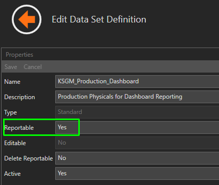
In order to make data available to other enterprise systems set the Reportable option to Yes in the Dataset Definition used in the Data Feed Out . A reportable dataset definition will write data to the RPM OmiReport database and can be used to expose XECUTE data as an SQL view. Views can then be used as data sources from other reporting tools such as Microsoft PowerBI. Contact the RPM consulting team for assistance with data integration.
The image below shows the Reportable configuration setting in Integration Management Studio (IMS) for a Dataset Definition that is used in a Data Feed Out in XECUTE Config.
Stage plans represent the as-built surface of the mine plan at a point in time. Stage plans can be exported as a surface or as a grid.
To export a stage plan, run the schedule to the desired point in time, open the 3D Scene radial menu and click the Export Stage Plan icon.
The exported file is named [Site Name] stage plan [date-time], for example KSGM stage plan s2019-08-06 0600.dxf.
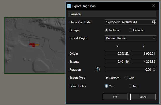
The image below shows a defined region to export a surface type staged plan. The green preview box on the left is adjusted as the origin and extents values are adjusted. The default setting is to export all extents.
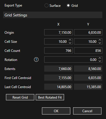
If the Grid option is chosen an additional panel appears to set the grid specification and the grid is rendered in the preview with a red cross to mark the origin.
Fields on the Stage Plan dialog
| General | Stage Plan Date | The schedule date-time at which the stage plan is generated. |
| Dumps | Option to include the upper surface of imported dump solids in the export. | |
| Export Region | All topography extents (default) or a user Defined Region. | |
| Origin | Enabled if the Defined Region option is selected. The south-west corner of the export region. | |
| Extents | Enabled if the Defined Region option is selected. The distance along the surface axes from origin to north-east corner. | |
| Rotation | Enabled if the Defined Region option is selected. Rotation of the region to export. Rotation is clockwise degrees relative from the +ve Y axis around the Z axis. | |
| Export Type | Tri-surface (Surface) or grid. | |
| Filling Holes | Will attempt to triangulate any stage plan inner holes. | |
| Grid Settings | Origin | The south-west corner of the export grid (cell edge). |
| Cell Size | The grid cell size. | |
| Cell Count | The grid cell count. | |
| Rotation | Rotation of the grid cells. Rotation is clockwise degrees relative from the +ve Y axis around the Z axis. | |
| Extents | The distance along the grid axes (cell edges). | |
| First Cell Centroid | The centroid of the south-west grid cell. | |
| Last Cell Centroid | The centroid of the north-east grid cell. | |
| Reset Grid | Reset the grid to the values in the General section. | |
| Best Rotated Fit | The grid is sized to best fit the rotated axis |
Supported formats for surface exports.
Supported formats for grid exports.